Every day you go to work or to class, and every day you get stuck on the same road due to traffic. AND if I could anticipate the traffic? Thanks to Google Maps you can do it and the best thing is that it is much simpler than you think.
Because the Google Maps application allows you to know the usual traffic which is on a path, to know what is the best departure time a depending on the time you want to arrive at a place.
How much traffic is there normally on your route? Find out with Google Maps

With Google Maps you can find out how much traffic there is usually on a route.
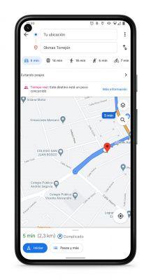
Normally, Google Maps shows it state of traffic when setting a route and start navigating to your destination. However, it is not necessary to go to a place to check for traffic jams.
Check the normal traffic on Google Maps on a route is easy. You just have to follow these steps:
- Open Google Maps and enter a destination in the search bar above.
- Tap the blue button at the bottom that says "Get started" to see the details of the route.
- Now tap on the three-dot icon in the top right corner of the screen, then tap on the 'Set departure or arrival time' option.
- In the menu that opens, choose the time you usually leave for your destination, or the time you should arrive. Then, tap on the text that says "Today" and choose a date. It is best to try different dates to get an idea of the traffic status each day.
- Finally, tap accept and then "Define". Wait for the route to load.
When you are done with the process, you will see a indicator showing the usual traffic and the time it should take to arrive.

Although the traffic status can vary for any reason, the truth is that the traffic information on Google Maps they are generally very accurate and will undoubtedly be of great help, especially when traveling to a new destination whose status is unknown. traffic along the route or to find a alternative route faster with less traffic to get to the same place.


